(1).jpg)


Notify me when back in stock
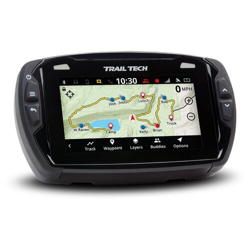
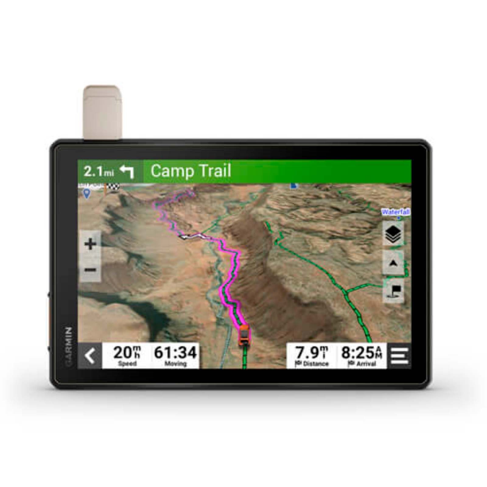
GARMIN TREAD OVERLAND MOTORCYCLE NAVIGATOR
ROAM THE UNKNOWN
Built for every part of the journey, this extra big, extra rugged all-terrain sat-nav has the mapping you need to stay on track and communication technology to stay in touch while you’re out there.
FEATURES:
- Navigate unpaved roads and trails by using turn-by-turn trail navigation with OpenStreetMap (OSM).
- Custom routing for the size and weight of your rig and preloaded iOverlander™ points of interest (POIs) help you find where to set up camp.
- This rugged sat-nav is IP67 weather-resistant and has a 10? ultrabright touchscreen display.
- See vivid aerial views of terrain with downloadable, subscription-free BirdsEye Satellite Imagery.
- Peace of mind comes built-in. With an active subscription, you can use inReach® technology for global satellite communication.
SPECIFICATIONS:
- PHYSICAL DIMENSIONS: 9.9"W x 7.8"H x 1.2"D (25.2 x 19.9 x 3.1 cm)
- DISPLAY SIZE: 8.5"W x 5.3"H (21.7 cm x 13.6 mm); 10.1" diagonal (25.7 cm)
- DISPLAY RESOLUTION: 1,280 x 800 pixels
- DISPLAY TYPE: Multi-touch, glass, high brightness HD colour TFT with white backlight
- DUAL-ORIENTATION DISPLAY: Yes
- WEIGHT: 32.8 oz (930 g)
- BATTERY TYPE: Rechargeable lithium-ion
- BATTERY LIFE: Up to 6 hours at 50% backlight, Up to 1 hour at 100% backlight
- WATER RATING: IPX7
- DROP RATING: MIL-STD-810
- MAGNETIC MOUNT: locking magnet-assisted mount
- 1.5" BALL ADAPTER WITH AMPS PLATE: Yes
- PRELOADED STREET MAPS: Yes
- HIGH DEFINITION 3D TERRAIN: Yes
- DATA CARDS: microSD™ card (not included)
- 3D TERRAIN: Yes
- INTERNAL STORAGE: 32 GB
- ABILITY TO ADD MAPS: Yes
- EXTERNAL MEMORY STORAGE: Yes (256 GB max microSD™ card)
- DOWNLOADABLE SATELLITE IMAGERY: Yes (BirdsEye)
- GPS: Yes
- COMPASS: Yes
- GALILEO: Yes
- 10 HZ MULTI-GNSS POSITIONING: Yes
- BAROMETRIC ALTIMETER: Yes
- POINT-TO-POINT NAVIGATION: Yes
- PRELOADED TOPOGRAPHICAL MAPS: Yes
- PRELOADED US PUBLIC LAND BOUNDARIES: Yes
- PRELOADED PRIVATE LAND PARCEL MAPS: Yes (parcels greater than 4 acres)
- PRELOADED USFS ROADS AND TRAILS, INCLUDING MOTOR-VEHICLE-USE-MAPS FOR MOTORCYCLE, ATV, SXS AND FULL-SIZE 4X4: Yes
- NAVIGATE-A-TRACK NAVIGATION: Yes
- TURN-BY-TURN TRAIL NAVIGATION: Yes
- GARMIN REAL DIRECTIONS™ LANDMARK GUIDANCE: Yes
- ROUTE SHAPING THROUGH PREFERRED CITIES/STREETS: Yes
- INCLUDES TRAFFIC: Yes (with Garmin Tread app)
- LANE ASSIST WITH JUNCTION VIEW (DISPLAYS JUNCTION SIGNS): Yes
- SPEED LIMIT INDICATOR (DISPLAYS SPEED LIMIT FOR MOST MAJOR ROADS IN NEW ZEALAND AND AUSTRALIA): Yes
- DRIVER ALERTS FOR SHARP CURVES, SCHOOL ZONES, RED LIGHT AND SPEED CAMERA WARNINGS AND MORE: Yes
- ENVIRONMENTAL ZONES ROUTING: Yes
- WI-FI® MAP AND SOFTWARE UPDATES: Yes
- REQUIRES BLUETOOTH®-ENABLED SMARTPHONE: Works with BLUETOOTH-compatiable helmet, headset or smartphone; BLE capable.
- GLOVE-FRIENDLY TOUCHSCREEN: Yes
- CONTROL MUSIC AND MEDIA FROM SMARTPHONE OR MP3 PLAYER: Yes
- SUNLIGHT READABLE AND WEATHER RESISTANT: Yes
- GARMIN ADVENTUROUS ROUTING: Yes
- MOTORCYCLE OR POWERSPORTS SPECIFIC POINTS OF INTEREST FOR CYCLE REPAIR SERVICES, DEALERS AND MORE: Yes
- ELEVATION PROFILE: Yes
- ROUND TRIP ROUTING: Yes
- SPECIALIZED ROUTING FOR THE SIZE AND WEIGHT OF YOUR VEHICLE: Yes
- PAIR WITH GARMIN POWERSWITCH™ DIGITAL SWITCH BOX: Yes
- COMPATIBLE WITH EXTERNAL GPS ANTENNA WITH MOUNT: Yes
- COMPATIBLE WITH EXTERNAL INREACH® SATELLITE ANTENNA: Yes
- GROUP RIDE MOBILE: Yes (with Garmin Tread app)
- TRACK RECORDER (BREADCRUMBS): Yes
- PITCH AND ROLL GAUGES: Yes
- DOG TRACKING: Yes (when paired to compatible dog track system)
PLEASE NOTE: ONLINE ONLY
(WHI_GA0100250920)
| SKU | WHI_GA0100250920 |
| Barcode # | GA0100250920 |
| Brand | Garmin |